Last post, we began the process of redesigning a yard by clarifying what are the goals we want to achieve. Today, let’s begin our look at one of the next steps in the landscape design process, creating your base plan. Then in a few posts, we will begin our site assessment.
PS Next time, we will take a one post break from this process and profile a great tree I have not written about before.
Drawing the Base Plan
Your base plan will be the foundation for your site assessment and landscape design. If you make mistakes here or leave off information, they will show up in your final landscape design.
You should draw your house and property to scale, allowing either a quarter inch per foot if you have a small area or if you have a larger yard, allow 1/8th an inch per foot.
If you don’t have graph paper, you can click on this link to go to a site where you can print some.
Start with your house
The first step in creating your base map is to add any buildings to your base plan. For this step you can use your plat of survey, building plans, or make your own measurements.


Add hardscapes and lot lines
The second step is to draw the:
- Property lines
- Driveways and sidewalks,
- Decks and patios, and
- Edge of the Road.
You should also add any easements, right of ways and set back lines noted on the plat.
Plat of survey from when you bought your home, you can get all of these off of it. This will make this step much easier and more accurate.
It’s almost always easier to revise a plat of survey with any changes that have occurred since than it is to draw a plan from scratch.
If you have a complicated house or yard layout AND don’t have a plat of survey, you might want to have a survey of your property done. This cost will vary depending upon where you live and how large your property is, but in most cases expect to pay between $350 to $650.
Add utilities, vegetation and details
The third step is to add more details to your house drawing that probably are not even on your Plat of survey.
Probably the most import things you must locate is the location of utility lines including water, natural gas, electrical, phone and cable.
You should call your States Utility locate service to have them locate where the utilities in your lot are buried. They will not locate private lines that may have been installed such as a gas line out to a grill.
In Illinois it is called JULIE, in Wisconsin it is called Digger’s Hotline. You can go this website call811.com to find out your states. This should be a free service.
You will also want to locate the following:
- Any existing trees or shrubs.
- The location of doors & windows, including how high off the ground,
- Location of gutter downspouts,
- Basic floor plan showing which rooms go with which windows,
- If you have a septic system you will want to locate the septic lines, field and tank.
How to locate trees out in your yard
You can use a process known as triangulation to locate existing trees, the known corners of your property or any other object out in your yard.
Basically, just measure the distance to your object from two known points, like the corners of your house.

Then on your site map draw arcs using a compass the lengths you measured. Where the lines cross is where the object you measured is.

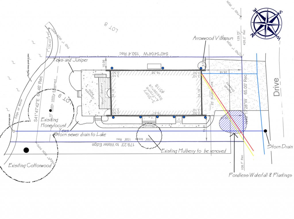
Completed base map
Once you have added all of these elements to your Base map, it will be complete and we will be ready to begin the process of site assessment.
Here is what my completed base map drawn on top of a copy of my plat of survey looks like:
Greg Sungreen says
The process of redesigning a yard has to be clarified according to the goals you want to achieve. A base plan has to be drawn, and that has to be started with your house.